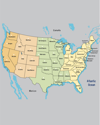
This colour map of the United States is a great resource for children and adults alike. Labelled with the full names of all 50 states, the map provides a clear and visually appealing guide to U.S. state geography.
Colour-coded time zones make it easy to see which U.S. states are in the same zone, while clearly marked state lines help you grasp U.S. geography at a glance. Alaska and Hawaii are both shown too, so all 50 states are represented.
This map of the United States includes the full name of each state, with no abbreviations to puzzle over.

| Language | Free |
| Release Date | 2022 |
| Genre | maps |
| Author | PDFGram™ |
| File Size | https://pdfgram.com |
| Rating | (5) |
Whether you’re a parent wanting learning resources to reference at home, or a teacher looking for a clearly labelled map of the United States for the classroom, this map is ideal for helping kids learn U.S. geography.
Because it uses full state names instead of abbreviations, this colour map of the United States is easy for learners of any age to understand. An appealing, easy-to-read font makes the map appear friendly and attractive to students, while the pastel colours will add a charming character to your classroom display.
When you’re helping children learn about different time zones, the clear colour coding on this map of the United States gives them a useful visual clue to how time differences operate and shows which states share a time zone.
Take students on a visual journey from the dark orange Pacific Time Zone on the West Coast, through the pastel orange Mountain Time Zone and the green Central Zone, until you reach the yellow Eastern Zone.
All four time zones in the contiguous United States are clearly represented, so you can use the map as a starting point to encourage kids to work out the time difference between states in the various zones. It’s also a great way to demonstrate how time zones depend on longitude – did you know, for instance, that a time zone is the equivalent of 15˚ of longitude?
Perhaps you’re a student revising for a quiz or an adult wanting to expand your world knowledge. Either way, this labelled colour map of the United States is a great resource to support you in your studies.
Print a copy and hang it on your wall or download the map to your device to give you an instant visual reference you can use to help you learn. The fully labelled states and clear state lines make it easy to pinpoint exactly where each state is and who it shares borders with.
Since the names of the states are written in full on this map (no abbreviations), it is also a great tool for learning how to spell even the trickiest names. How many N’s are in Tennessee? How many S’s in Mississippi? You won’t be caught out again with this map of the United States to prompt you.
No matter how good your grasp of geography is, having a quick visual reference to the U.S. states in your office can save you time and help you avoid simple mistakes. If your company works across different regions, this map of the United States is especially useful because it gives you an easy guide to which states fall into each time zone.
Plus, with this clearly labelled map of the United States to hand, you’ll soon find yourself a whizz in the geography category of every trivia quiz. Which states share a border with Colorado? How many U.S. states begin with the letter M? The attractive design of this map makes it easy to bring it to mind and recall all the details you need.
So, if you’re looking for a labelled map of the United States with full state names and time zones, you’ve come to the right place. Whatever your needs are, download this map today to make sure you have it when you need it.