| Language | Free |
| Release Date | 2022 |
| Genre | maps |
| Author | PDFGram™ |
| File Size | https://pdfgram.com |
| Rating | (5) |
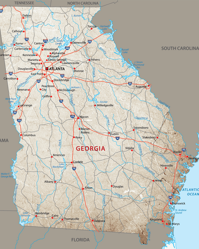
The usage of the map can vary depending on whether it is for the classroom or at home. Teachers looking to utilize this map to inform students on topics centering around Georgia will find this map to be an impactful tool. It is complete with to-scale data that shows everything from the major bodies of water in the city to the highways running through the state. Whether teachers are hoping to educate their students on the state’s modern history or fascinating past, this map is a tool that can drive home key points using visual backup to ensure students retain the knowledge.
The map can also have a place in enterprise as well. If you are preparing a report or presentation and need an up-to-date state map highlighting the key cities, towns, roads, and more, this Georgian map will be an important resource. If you want to ensure that your next map visual is trustworthy, modern, and legal for use, this is an option that takes the difficulty out of the process.
Some may think maps are easy-to-find. However, the certainty that comes from a map that is highly accurate, to-scale, and available to be used across settings goes a long way. You can be confident in the reliability of the map offered and not worry about copyright concerns or any other substantial issues. Instead, focus on the big picture and feel confident you are using the ideal map for you.
While it covers much primary information about Georgia, there is still room for editing and expansion. The map shows state borders, waters intersecting with Georgia, and many of the main cities and towns in the state. It is color-coded to effectively convey the necessary information. But while it shows many details, more details can be added. The map can be printed, edited, and altered to suit unique needs, and while it showcases the basic information one would expect from a map of the state, more can be added.
Maps are crucial tools that are used by people around the world. They are the best way to understand the size, scale, and structure of an area, and an accurate map can provide invaluable information that is useful across mediums.
If you are hoping to learn more about Georgia, there is no better way than one of our highly-accurate, up-to-date state maps. Our Georgia maps will offer crucial guiding insights on one of America’s best-known states, whether for the classroom, workplace, or personal interest.